
Our Core Responsibilities
DSD is committed to providing professional sewage treatment and stormwater drainage services to the public so as to protect the quality of Hong Kong waters and protect the citizens against flooding. Since our establishment in 1989, we have been endeavouring to build excellent sewerage and drainage facilities to make Hong Kong a more livable city.
Overview of Flood Prevention in 2017-18
There were drastic climate changes in 2017, with frequent typhoons and rainstorms. The storm surge caused by Super Typhoon Hato which hit Hong Kong in August led to severe flooding in many coastal areas of the city, posing new challenges to our flood prevention works.
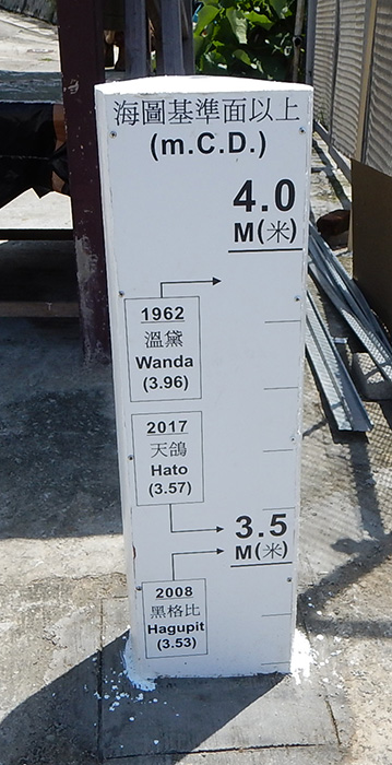
The annual total rainfall in 2017 was 2,572 millimetres, slightly higher than the mean annual total rainfall of approximately 2,400 millimetres by approximately 7.2% between 1981 and 2010. In 2017, the Hong Kong Observatory (HKO) issued one Black, four Red and 15 Amber Rainstorm Warnings. The only Black Rainstorm Warning was issued on 24 May, on which day many areas recorded a maximum hourly rainfall of 100 millimetres. Extreme and localised precipitation events were also become more frequent. On 18 July, HKO issued three Amber Rainstorm Warning in total. Tai Po district, however, recorded a rainfall of 135 millimetres within two hours, an amount equalling that of Black Rainstorm Warning. During the year, HKO also issued five tropical cyclone warning signals No. 8 or above, matching the records in 1964 and 1999. Coinciding with the astronomical high tide during the attack of Super Typhoon Hato on August 23, the sea level at Quarry Bay peaked at 3.57 metres above Chart Datum, the second highest record since 1954 and only lower than the record high of 3.96 metres above Chart Datum set by Super Typhoon Wanda in 1962. A maximum sea level of 4.56 metres above Chart Datum was recorded in Tsim Bei Tsui, the highest since records began in 1974.
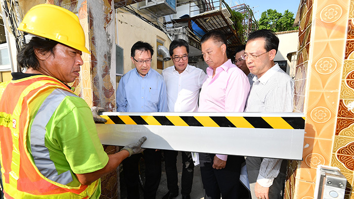
To minimise the flooding risk arising from the Super Typhoon Hato, DSD stepped up inspections and clearance of major drainage channels and inlets, particularly at flooding blackspots, to ensure that the drains are free from obstruction. Besides, we had identified several low-lying coastal areas that are susceptible to flooding arising from storm surge, such as Tai O, Lei Yue Mun and Nam Wai in Sai Kung. The Government has installed flood prevention facilities such as the construction of flood wall and installation of tidal gate and non-return flap valve. Also, the HKO had established an early alert system for the said locations. When storm surge alerts were issued by the HKO, DSD implemented emergency flood relief measures at relevant locations immediately with an aim to alleviate the flooding impact. Taking an example in Tai O, before the typhoon arrived Hong Kong, DSD deployed over 10 staffs staying in Tai O to install the temporary water-stop boards over the midnight to enhance the flood protection capacity of river wall and to handle emergency situations.
During the severe weather and before the Tropical Cyclone Warning Signal No. 8 is in force, we had activated the Emergency Control Centre and contingency teams were deployed to stand by at the locations prone to flooding, to ensure that inspections and drain clearance would be conducted in time to reduce flooding risk. Around 120 staffs under 30 teams had been mobilised.
Striving to prevent flooding, DSD has designed and constructed drainage facilities with primary reference to international standards, and carries out regular inspections and maintenance works to ensure proper operation of our facilities. In 2017-18, DSD continued to implement various flood prevention projects. Meanwhile, we are reviewing the Drainage Master Plans (DMPs) of various districts in stages, so as to upgrade their flood protection level and tie in with Hong Kong’s future development.
Bringing Down the Number of Flooding Blackspot
We implemented various drainage improvement works in the past year, and after evaluating the effectiveness of each completed drainage improvement works, we removed the flooding blackspot at Tung Tsz Road in Tai Po in early 2018, thus reducing the total number of flooding blackspots in the territory from seven to six. Among the six remaining flooding blackspots, drainage improvement works for two have been commissioned and their effectiveness is being monitored. In order to remove all the flooding blackspots as early as possible, the first stage improvement works for the other four blackspots have been completed while the next stage improvement works are under planning and design. We will closely monitor the drainage condition in these areas during the rainy season.
Total Number of Flooding Blackspots

Overall Flood Prevention Strategy of Hong Kong
Compounded by urbanization, increase in surface runoff and reduction of flood plains, flooding may happen at certain districts in low-lying areas and coastal areas. To address the flooding problem in various places, we have developed a “three-pronged flood prevention strategy”, i.e. stormwater interception, flood storage and drainage improvement, which has been proven effective in mitigating the flood risk arising from heavy rain.
- Stormwater Interception: build drainage tunnels to intercept stormwater from the mid-levels and discharge it directly into the sea or to other channels and drains
- Flood Storage: build storage tanks in the midstream for temporary stormwater storage to relieve the discharge load of the downstream drainage system
- Drainage Improvement: carry out river training works or build new drainage channels and drains to upgrade the capacity of drainage system
Three-pronged in Flood Prevention Strategy

To support the sustainable development of Hong Kong and combat climate change, we adopt the “Sponge City” concept of “following the nature with resilience” to facilitate infiltration and reduce surface runoff through flood storage and retention. Part of the stormwater is collected and reused in a bid to optimise water recycling across the city and enhance the flood resilience level of the city.

Operation and Maintenance of Existing Drainage Facilities
A clear drainage system is prerequisite to flood prevention. There are about 2,400 kilometres of underground stormwater drains, 360 kilometres of engineered channels, 21 kilometres of drainage tunnels, and four underground stormwater storage tanks in Hong Kong, all managed by DSD. During the year, we inspected over 2,290 kilometres of drains and rivers. Apart from regular inspections and preventive maintenance works, we conduct regular functional and structural checks and clear blockages before and after the wet season.
![]()
Emergency and Response
- Emergency and Storm Damage Organisation (ESDO) operates round the clock to coordinate the dissemination of information relating to emergencies and allocation of resources, as well as to liaise with other government emergency units
![]()
Flood Storage
- During heavy rainstorms, some stormwater in urban areas is diverted to storage tanks for temporary storage to relieve the burden of downstream drainage systems
- Four stormwater storage schemes at Tai Hang Tung, Sheung Wan, Happy Valley and On Sau Road are now in operation
- To further relieve the flood risk in Kowloon, various stormwater storage schemes have been formulated and are under planning for further investigation
![]()
Interception
- Stormwater is intercepted at upstream and diverted for direct discharge to the sea or rivers, thereby substantially mitigating the flood risk in downstream areas
- Obviate the need for large-scale drainage improvement works in downstream urban areas, thereby reducing the impacts on traffic and the public
- Four drainage tunnels, including Kai Tak Transfer Scheme, and Hong Kong West, Lai Chi Kok and Tsuen Wan Drainage Tunnels, totalling about 21 kilometres in length, have been in operation for years
![]()
Drainage Improvement
- Drainage improvement works are carried out to straighten, widen and deepen rivers and to construct or enlarge underground drains
- Over 100 kilometres of rivers have been improved and about 93 kilometres of drains upgraded to date
Planning, Design and Construction of New Drainage Facilities
Drainage Master Plan (DMP) Review Study
To tie in with Hong Kong's future development and adapt to climate change, we have conducted DMP review studies and drainage studies on the whole territory of Hong Kong. The review studies of DMPs for Yuen Long and North District in the New Territories and Happy Valley were completed in 2011 whereas the improvement works at Happy Valley have been fully commissioned since 2017. The DMP Reviews for West Kowloon and East Kowloon were also completed in 2015 and some of the proposed improvement works are under planning.

Current Progress
At present, the improvement works proposed on the studies for Yuen Long and North District in the New Territories are under design. Some proposed improvement works for West Kowloon and East Kowloon are also under planning. This year, drainage improvement works in Sha Tin, Sai Kung, Tai Po and Northern Hong Kong Island will also be formulated and the next stage of investigation is targeted to commence in 2019. As for Lantau and Outlying Islands, Repulse Bay and Tai Tam, Tuen Mun, Tsuen Wan and Kwai Tsing, the three DMP review studies are currently underway.

Kai Tak River Improvement Works
The project aims to improve the flood protection levels of East Kowloon by reconstructing and rehabilitating a some 1.1-kilometre section of the Kai Tak River from Po Kong Village Road to Prince Edward Road East. A box culvert of about 400 metres long will also be constructed alongside the river upstream. We hope to ride on the opportunity to upgrade the river’s drainage capacity and revitalise the river into an urban green river corridor for public enjoyment.
Current Progress
Upstream and midstream improvement works of Kai Tak River commenced in October 2011 and December 2013 respectively for scheduled completion in mid-2018. The estimated project cost is about $2.8 billion.
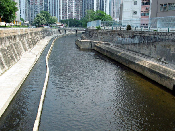
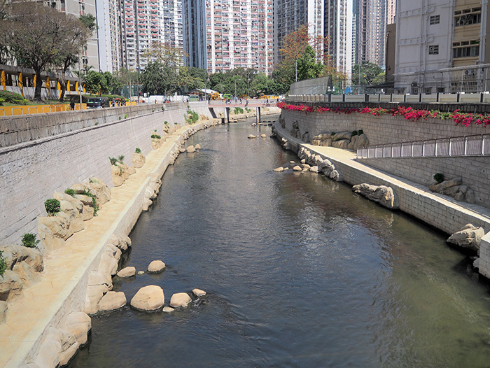
Kai Tak River before (left) and after (right) the Improvement Works
West Kowloon Drainage Improvement – Inter-reservoirs Transfer Scheme (IRTS)
In an attempt to enhance the flood prevention capacity of West Kowloon to cope with the challenges posed by climate change, we plan to construct a water tunnel with a total length of about 2.8 kilometres connecting Kowloon Byewash Reservoir and Lower Shing Mun Reservoir, which will transfer the surface runoff collected from the Kowloon group of reservoirs to Lower Shing Mun Reservoir. The IRTS will generate an annual additional fresh water yield of about 3.4 million cubic metres.
Current Progress
Construction works are scheduled for commencement in the first quarter of 2019 for completion in 2022. The estimated project cost is about $1.22 billion.
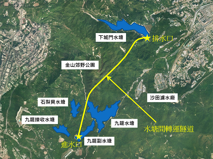
Location of Inter-reservoirs Transfer Scheme
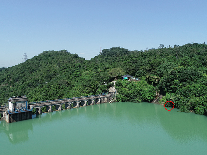
Location of the tunnel intake of Inter-reservoirs Transfer Scheme at the Kowloon Byewash Reservoir
Revitalisation of Tsui Ping River
Detailed design for the revitalisation works has already begun in December 2017. Through environmental, ecological and scenic enhancement, we are transforming a one-kilometre nullah along King Yip Street, King Yip Lane and Tsui Ping Road into Tsui Ping River. The project also beautifies adjoining pavements as well as improves connectivity and walkability by providing riverside walkways and landscaped decks.
Current Progress
We will be conducting revitalisation works in Kowloon East following the commencement of detailed design in December 2017. The stage two public engagement exercise will be conducted from May to July 2018 with activities including roving exhibitions and community workshops for collecting views on the project and the updated revitalisation plan.

Photomontage of Tsui Ping River


