
Flooding Blackspots
Flooding Blackspots
The Purpose
DSD established a systematic approach to identify flooding blackspots in the territory in 1994. The flooding blackspots list are produced based on drainage capacity, previous flooding records, complaints received and flood protection standards at the relevant location. Setting up flooding blackspots are effective for the planning of drainage improvement works. For the commissioned drainage improvement works, their effectiveness is being monitored.
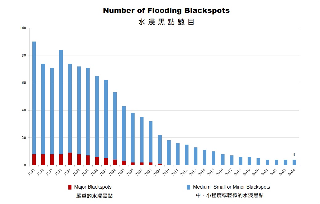
Number of Flooding Blackspots over the years
Flooding Blackspot Scales
Flooding blackspots shall be classified according to the extent of area affected and consequences experienced, namely Major (Level 4), Medium (Level 3), Small (Level 2) and Minor (Level 1). Definition of flooding blackspot scales is given as follow:
- Major - affecting area of more than 100 hectares or resulting in serious social and economic disruption.
- Medium - affecting area of more than 10 hectares or resulting in significant property damage or serious traffic disruption.
- Small - affecting area of more than 0.25 hectares or resulting in some agricultural damage, isolated property damage, or traffic disruption.
- Minor - affecting area of less than about 50 metres x 50 metres (area less than 0.25 hectare) or resulting in minor public nuisance and inconvenience.
Review Mechanism
DSD regularly reviews the flooding blackspot list. Addition of flooding blackspots shall consider factors including recent flooding records, extent and depth of flooding at the location. Deletion of flooding blackspots shall consider the effectiveness of the commissioned drainage improvement works with flood monitoring. In general, the flood monitoring period shall be about 3 wet seasons following completion of all the drainage improvement works.
List of Flooding Blackspots
Blackspots Location Map

Notes: The flooding blackspots list is for monitoring the effectiveness of the maintenance and mitigation measures at the blackspots. The flooding blackspots list should not be used as an indication of the actual or hidden flood risk at any particular location in Hong Kong. Locations susceptible to flooding problems dominated by tidal influence were not included. For impacts of storm surges and waves on coastal low-lying or windy locations under extreme weather and climate change, please refer to relevant section of our website for more information.