| DSD endeavours to continuously improving the drainage systems in Hong Kong for protecting the public against flooding. |
| Overview |
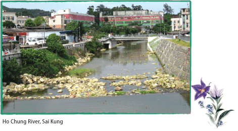
Since 1997, DSD has been implementing a $12 billion flood prevention programme in the NT, including more than 100 km river training works and 27 village flood protection schemes. The drainage improvement works in Tai Po Town area and Ho Chung River at Sai Kung were completed in 2009. In urban areas, a $9.6 billion programme of drainage improvement works to raise the flood protection level in the concerned catchments including the construction of Hong Kong West, Tsuen Wan and Lai Chi Kok drainage tunnels are now in satisfactory progress. These major flood control projects are listed in Appendix A, whereas locations of the projects are shown in Appendix B. Wing Lok Street in Sheung Wan is a low-lying area where flooding had occurred in the past under severe rainstorms and high tide conditions in Victoria Harbour. To solve the flooding problem in Sheung Wan, DSD had constructed stormwater intercepting drains and pumping station to pump stormwater of the low-lying area to the sea. Since the commissioning of Sheung Wan Floodwater Pumping Station in March 2009, no flooding case in Sheung Wan low-lying area has been reported. Apart from continuing with the implementation of planned flood protection projects, DSD is actively reviewing new flood protection needs. The Drainage Master Plan (DMP) Studies for Yuen Long and the Northern NT were completed in 1998 and 1999 respectively. The majority of the improvement works and river training works recommended in the Studies have been completed. However, in view of changes in land uses and new developments planned within the areas, DSD commissioned a DMP Review for Yuen Long and North Districts in March 2008. Taking into account of the major changes in land uses, new development proposals and town planning, numerical models for evaluating the hydraulic performance of the major rivers/channels are being set up. Further drainage improvement works for major rivers, upstream channels and the local flooding spots would be proposed by the Study which is expected to be finalized in late 2011. In respect of operation and maintenance, DSD continues to carry out preventive measures including inspection, desilting and repair works for drainage systems. In 2009-10, over 2,077 km of drains and watercourses were inspected and about $111 million was spent on such maintenance works. DSD always puts efforts in resolving issues related to problematic road gullies, stormwater intakes, drains and watercourses and inspects them on a regular basis especially before and during the rainy season. The operation and maintenance works carried out in the past years on flood prevention are shown in Appendix C. |
| Flooding Incidents in 2009 |
The year 2009 was drier than usual. The annual rainfall of 2,182 mm was about 8 per cent below the normal yearly rainfall of 2,382 mm. In 2009, no Black Rainstorm Warning Signal was issued while only 20 and 2 times of Amber and Red Rainstorm Warning Signals were issued respectively. Special Announcement on Flooding in northern New Territories was issued for 4 times in the year. Under the influence of a stronger than normal sub-tropical ridge, the weather was hotter than usual in August, September and October. It was also wetter than usual in September with a total rainfall of 486.3 mm, which was about 69 percent above normal. |
 |
| Other than Tai O, there are also other coastal low-lying spots in HK that were vulnerable to sea flooding during typhoon. To address the problem, DSD, Hong Kong Observatory (HKO) and HAD jointly established an Early Alert System for predicted storm surge in 2010. Under the Alert System, HKO would issue storm surge alerts to HAD and DSD. Upon receipt, HAD would inform concerned villagers to take necessary precautionary measures; and DSD would take emergency flood mitigation actions at appropriate locations. The Early Alert System was put into operation since April 2010. |
| Flood Prevention in NT |
| To resolve the flooding problem and to improve the drainage system in the NT, DSD has been implementing a series of major flood control projects in the NT areas at a total cost estimated to be over $12 billion since 1997. |
| Flood Prevention in NNT and NWNT |
Low-lying topography, insufficient drainage facilities and rapid urban development in the NNT and the NWNT were the main reasons in the past causing flooding during prolonged heavy rain and tropical cyclones. Since the late 1990s, DSD had already constructed about 77 km drainage channels to better collect and convey stormwater; and a number of village flood protection schemes to protect villages in low-lying areas. The completed 27 village flood protection schemes have protected 35 low-lying villages from flooding. Over 240 hectares of low-lying village area accommodating a population of 30,000 people are being protected. |
| NNT |
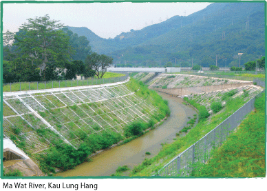
| In the past, serious flooding occurred in Lo Wu, Ho Sheung Heung, Yin Kong and Tin Ping Shan. After completion of a series of projects costing approximately $4.3 billion, flooding situation in the NNT has been alleviated. Completed major drainage channels include Ng Tung River, Sheung Yue River, Shenzhen River (from Deep Bay to Ping Yuen River section) and Ma Wat River. DSD is now improving the upstream and estuaries of major rivers to enhance the flood protection to upstream areas. In addition, DSD is carrying out a feasibility study on the training of upstream section of Shenzhen River from Ping Yuen River to Pak Fu Shan in order to cater for the recent development of Liantang/Heung Yuen Wai Boundary Control Point and more details are given in the Feature Article on Page 28-29. |
 |
 |
| NWNT |
| In the past, most areas in Tin Shui Wai, Yuen Long and Kam Tin in the NWNT were susceptible to flooding. The situation has been greatly improved since the active implementation of drainage improvement works by DSD in the past 20 years. The projects in the NWNT cost approximately $5.2 billion. Completed major drainage channels include Kam Tin River, Tin Shui Wai River, Ngau Tam Mei River, San Tin Eastern River and Yuen Long Bypass Floodway. Two drainage channel projects are being carried out in Kam Tin. The lengths of channels involved are 2,000 m and 2,300 m respectively. The first project has been substantially completed, while the other is scheduled to be completed in January 2011. We will continue to carry out drainage improvement works in secondary and tertiary drainage channels at the upstream of NWNT basins. |
Flood Prevention in Other NT Areas |
 |
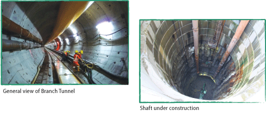
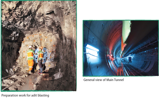
Flood Prevention in Urban Areas To address the flooding problem in Lai Chi Kok, DSD is constructing the Lai Chi Kok Drainage Tunnel (LCKDT) at a total cost of $1.7 billion. The works commenced in late 2008 and is scheduled for completion in 2012. The LCKDT is 4.9 m in diameter and comprises two segments – a Branch Tunnel and a Main Tunnel, of a total length of 3.7 km. The Branch Tunnel runs along Ching Cheung Road from Chak On Estate to Butterfly Valley. It comprises six intakes for intercepting runoff from the upper rural areas. The flow is then discharged via the Main Tunnel which runs southwards from Butterfly Valley to Victoria Harbour. The tunnels are being constructed by a state-of-the-art slurry shield Tunnel Boring Machine (TBM). Boring for the Branch Tunnel started in March 2010 and works are in steady progress. |
|
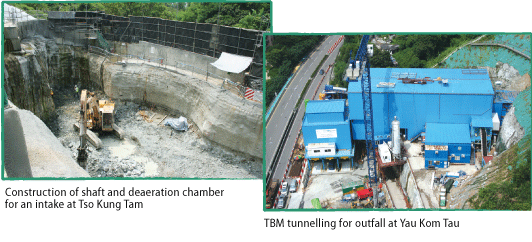
| Tsuen Wan DSD is also implementing Tsuen Wan Drainage Tunnel (TWDT) to relieve the flood risk in Tsuen Wan and Kwai Chung areas. This project consists of a 5.1 km long drainage tunnel with an internal diameter of 6.5 m, three intakes at Wo Yip Hop, Lo Wai and Tso Kung Tam respectively, an outfall at Yau Kom Tau and the associated greening works. The main tunnel would be constructed by a double-shield TBM with which tunnel linings could be installed shortly after tunnel boring. It prevents excessive loss of ground water and minimises the associated ground settlement problem. The TWDT project costs around $1.1 billion and commenced in late 2007 for completion in 2012-13. |
 |
Hong Kong Island HKWDT is our major initiative to enhance the flooding protection in Northern Hong Kong Island. Upon project completion, the 11 km long tunnel will intercept stormwater from the upper catchment at the mid-levels from Tai Hang to Kennedy Town and discharge it to the sea near Cyberport, thus reducing the volume of rainwater flowing to the downstream low-lying areas including Sheung Wan, Central, Admiralty and Wan Chai. This tunnel project also includes 34 intakes located in Mid-levels and 8 km long connection adits. The design-and-build contract commenced in late 2007 for completion in 2012-13. The drainage tunnel is being constructed by two TBMs of 7 m and 8 m diameters from the east and west sides of the tunnel. It is expected that the excavation of main tunnel will be completed in early 2011. The construction of intakes will be proceeded in phases. The intake construction works, comprising intake structure, drop shaft and adit, at 20 intake locations have been commenced. |
 |
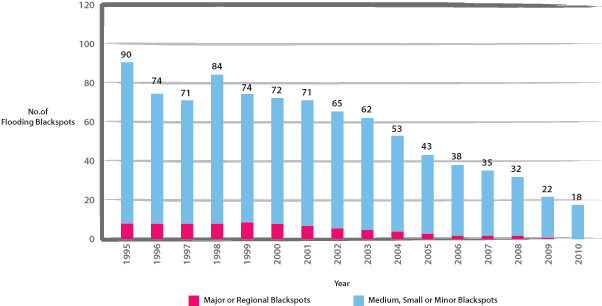
Reducing Flooding Blackspots |
| Change in Total Number of Flooding Blackspots |
 |
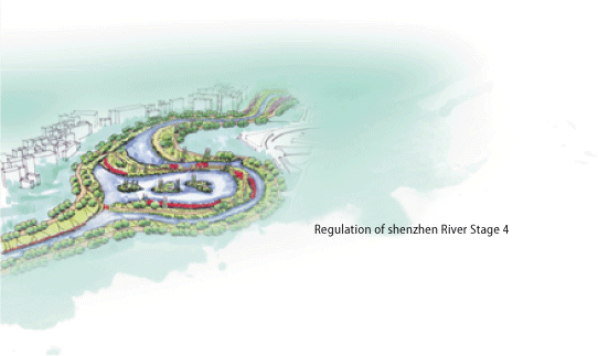 |
| Feature Article : Regulation of Shenzhen River Stage 4 (Liantang Heung Yuen Wai Section) |
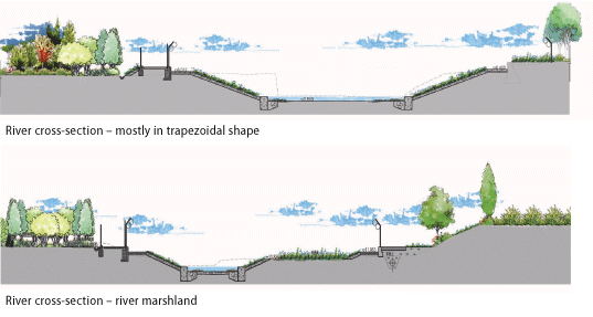
Shenzhen River is the boundary river between Shenzhen and Hong Kong. From 1995 to 2007, Shenzhen and Hong Kong have jointly completed the Stages 1, 2 and 3 of the Regulation of Shenzhen River project to alleviate the flooding problems in the surrounding areas. The regulated Shenzhen River, with a total length of about 13.5 km, includes the section between its junction with Ping Yuen River to the estuary of Shenzhen River. To alleviate the flooding problems in the unregulated upstream section of the Shenzhen River, and to match with the construction of the Liantang/Heung Yuen Wai Boundary Control Point and the development of the northern New Territories, Shenzhen and Hong Kong will jointly implement the Regulation of the Shenzhen River Stage 4 project. The project will be jointly implemented by the Hong Kong Drainage Services Department and the Shenzhen Water Affairs Bureau. The section of the Shenzhen River to be trained under Regulation of Shenzhen River Stage 4 project is about 4.5km long, which is further upstream of the trained river section under Stage 3 project between the confluence of Ping Yuen River and the north-east of Pak Fu Shan. The scope of the Stage 4 project includes widening of river channel, construction of river embankment and construction of a flood retardation basin, with a view to improving the flood prevention capacity to withstand 50-year rainstorm. An ecological river concept will be adopted in designing the Regulation of Shenzhen River Stage 4 project. The alignment of the proposed river will follow the existing river as much as possible, instead of using the traditional method of straightening the river. The cross-sections of the river will mostly be in trapezoidal shapes, with grasscrete panels on the sloping surfaces of the river embankments; while rip-raps or in-situ natural river bed materials will be used for the new river beds instead of using concrete bedding. Meanwhile, the existing river bends will be kept and improved as river marsh lands to provide suitable ecological habitats for the Shenzhen River. The largest existing river bend will be designed as a flood retardation basin, which will greatly enhance the ecological value of the Shenzhen River, and at the same time temporarily store floodwater during heavy rainstorms to control the downstream water level. Upon completion, the project will alleviate the flooding problem in the vicinity, and also enhance the ecological value of the adjacent areas. The river training works is scheduled to commence in 2012 for completion in 2017. The Hong Kong’s share of the project cost is estimated to be about HK$800 million. |
 |