Overview Through the continued effort of the Government, most parts of Hong Kong have been protected against flooding to a reasonable degree. However, flooding can still occur on the natural flood plains and low-lying areas of the northern part of the NT, and in the older urban areas, like West Kowloon, because of the inadequacy of the drainage system constructed long ago.
To mitigate the problem, DSD has been implementing a $10.7 billion flood prevention programme of river training works and village flood pumping schemes in the NT, and a $3.5 billion programme of urban drainage improvement works in West Kowloon to raise the standard of flood protection substantially. Since 1997, about 60km of rivers in the northern parts of NT have been trained with 25 village flood pumping schemes in operation, bringing relief to the flooding situation in Northern NT and North-western NT. Since 1995, we have removed 87 flooding black spots in both the urban and rural areas. To further improve the situation,
we are planning a comprehensive programme of drainage improvement works
aimed at providing Hong Kong with a high degree of flood protection to
satisfy the future need of the community. |
Flooding Incidents in 2005-06 In 2005, the annual rainfall depth was around 3,215 mm, significantly higher than the average of 2,214 mm by about 45%. Amber Rainstorm Warning Signal was hoisted 16 times. Red Rainstorm Warning Signal was only hoisted in the morning on 24 June 2005, which mainly affected the Northern NT, East Kowloon and Western Hong Kong Island, in particular Wing Lok Street in Sheung Wan and Smithfield Road in Kennedy Town. There were minor flooding events in Sheung Shui, Tai Po and Ta Kwu Ling areas. In particular, the flooding in Sheung Wan and Smithfield Road has aroused much concern of the public. To alleviate flooding in Sheung Wan, an intercepting drain commenced construction in March 2006 and a floodwater pumping station commenced construction in July 2006 for completion in 2009. Before completion of the work, a system of sending flood warning in SMS or voice message, namely Sheung Wan Flood Watch, was launched in April 2006 to alert residents and shopkeepers in Sheung Wan of possible flooding in order to minimize losses. Due to the overshooting of
floodwater from the U-channel system at Smithfield Road, measures which
included the installation of additional grilles at upstream of the channel
were taken to resolve the problem. In addition, more than half of the
flow at the concerned U-channel will be diverted to the drainage system
of Hong Kong West Tunnel for completion in 2011. |
Flood Prevention in NT To solve the flooding problem in the Northern and North-western NT, the Government has commenced a series of major flood control projects at a total estimated cost of about $8.8 billion. In the Northern NT, $2.4 billion of works have been completed, and about $0.8 billion of construction projects are in progress. In addition, new drainage improvement projects under various planning and detailed design stages are estimated to cost a total of $0.9 billion. In the North-western NT, the costs of the completed works, on-going construction projects, and flood control projects under planning and design stages are estimated at $3.8 billion, $0.6 billion and $0.3 billion respectively. Flood prevention projects in the NT can broadly be classified into two main types, namely drainage channels to collect and convey floodwater to the sea and village flood pumping schemes to protect villages in low-lying areas. 
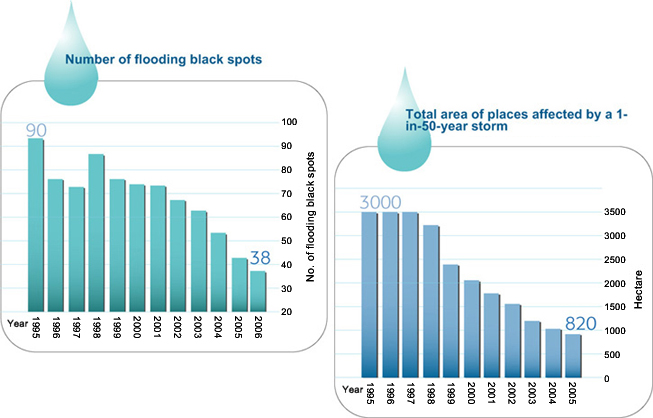
With the completion of drainage channels in recent years, the flooding situation in the NT has been significantly improved, particularly in Lo Wu, Ho Sheung Heung, Yin Kong and Tin Ping Shan in the Northern NT and Tin Shui Wai, Yuen Long and Kam Tin in the Northwestern NT. In the past, floodplains in the NT were often susceptible to flooding to 1 to 1.5 m depth as overflow took place along the old river sections which were narrow and sinuous. Nowadays, tens of thousands of people in these flood prone areas have been relieved of flood risks. As regards low-lying villages in the flood plain areas, we have already completed 25 village flood pumping schemes to remove the flood risks at 33 low-lying villages. Over 240 hectares of low-lying villages areas accommodating a population of 30,000 people are now being protected. 
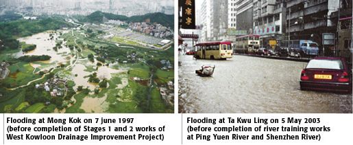
In the Northern NT, the rehabilitation of Ping Yuen River has been completed and the Stage 3 works of the Shenzhen River Regulation Project was in good progress. Upon completion of Shenzhen River Regulation Project, the flooding situation at Lo Shue Ling, the last regional flooding black spot in the Northern NT, will be significantly improved. 
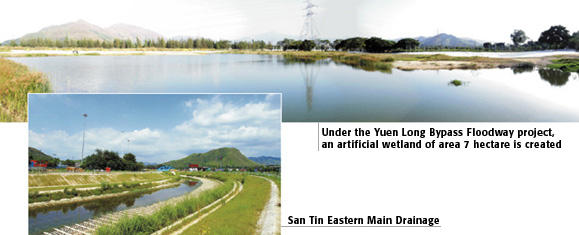
In the Northwestern NT, construction works of Yuen Long Bypass Floodway and San Tin Eastern Main Drainage Channel, as well as the village flood pumping scheme at Mai Po Lo Wai/Mai Po San Tsuen were completed. Construction work of village flood pumping schemes at Tai Kiu and Shui Pin Tsuen were progressing well. Plans are also in hand to improve the stormwater drainage systems in Tuen Mun, Sha Tin, Tai Po, Tsuen Wan, Sai Kung and the Lantau Island. |
|
Flood Prevention in the Urban Areas Flood prevention projects in the urban areas mainly include improvements of the flow capacity of the stormwater drainage networks in order that stormwater would be collected and conveyed efficiently. Under some special circumstances, innovative methods such as flood storage, flood pumping or flow diversion are used to minimize the extent of works that may cause disturbances to traffic or conflict with underground utilities. In West Kowloon, a comprehensive programme for upgrading the drainage system at a total cost of $3.5 billion is underway. About 34 km of the stormwater drains have already been completed. Under Stage 3 of the West Kowloon Drainage Improvement Project, the construction of about 12 km of stormwater drains was in progress for completion in 2007. Construction of the Lai Chi Kok Transfer Scheme is tentatively scheduled to start in 2008 for completion in 2011, as this area is susceptible to flood risk due to surface runoff from the hinterland and the potential overflow from the Kowloon group of reservoirs. For flood prone areas in the Northern Hong Kong Island and East Kowloon, drainage improvement projects costing about $2.9 billion are being planned. In order to minimize the disturbance to the local residents and road traffic due to trench excavation, stormwater drainage tunnels will be constructed to divert stormwater away so as to reduce the loading on the existing drainage systems which have insufficient capacity. Reduce Flooding Black Spots Since 1994, DSD has identified
more than a hundred flooding black spots. All of the black spots are under
close surveillance. Improvement measures have been taken to eradicate
the flood risk. Last year, we have successfully removed five flooding
black spots. Since 1995, we have removed 87 flooding black spots in both
urban and rural areas. With the progressive completion of major flood
prevention projects, the flooding situation in some flooding black spots
and flood prone areas has been significantly improved. The progressive
improvements are summarized in the tables below: |
Flood Prevention for Sheung Wan Low-lying Areas Wing Lok Street is a well-known
flooding black spot of Central and Western District. The two flooding
events occurred on 24 June 2005 and 27 February 2006 have affected both
residents and shop owners in Sheung Wan low-lying areas and caught public
concerns. |
|
Wing
Lok Street is a low-lying area with the lowest road level of about 2.64mPD.
In the morning on 24 June 2005, a maximum hourly rainfall of 112mm/hr
was recorded in the western part of Hong Kong Island when a Red Rainstorm
Warning was hoisted at around 10:00am. This was coincident with the high
tide of 2.36mPD. Hence, stormwater could not drain out easily to sea at
such high tide condition. As a result, a maximum flooding depth of about
600mm above road level was recorded. Another flooding incident happened
at around 10:00pm on 27 February 2006 with a maximum flood depth of about
200mm under very small rain condition. This flooding was induced by seawater
back flow when high tide coupled with adverse wind surge resulted the
tide level reached to about 2.84mPD. |
|
|
|
As interim measures to minimize the flooding impacts, we have introduced more frequent drainage inspections and preventative maintenance works to the low-lying area. A "Wing Lok Street Flooding Control Contingency Plan" has been implemented under which a standby Emergency Team would be mobilized at Wing Lok Street to tackle flooding problems and complaints wherever necessary under exceptional adverse weather and/or high tide conditions. DSD has also launched a Sheung Wan Flood Watch System in early April 2006 for sending "Fllood Watch" message to alert concerned parties including residents and shopkeepers in Sheung Wan low-lying areas of possible flooding incident. On 17 May 2006, the system was effected and well received by concerned users and media. Regarding the long term solution
to alleviate the flooding problem, DSD will construct a drain running
along Lok Ku Road and Queen's Road Central to intercept stormwater at
upstream of Wing Lok Street. Works are scheduled for completion in 2008.
In addition, a stormwater pumping station at Chung Kong Road, Sheung Wan,
would be built to remove stormwater onto Wing Lok Street. Upon completion
of works in 2009, this low-lying area will be able to cope with a 1-in-50-year
storm, even under high tide condition. |
|