|
| Home | The Director's Statement | Our Vision, Mission and Values | Highlights of the Year |

|
| Overview | Ready for the Rainy Days | Let's Clean Up Our Water | Environmental Performance | Let's Contribute |


| Delivery of Our Projects
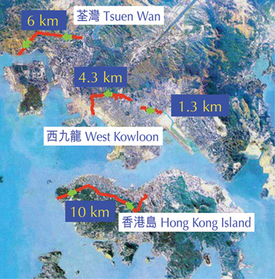
The Government is now constructing a series of major drainage improvement works to tackle the flooding problems, with active construction contracts costing about $3.2 billion for the Northern and Northwestern NT and about $3.3 billion for West Kowloon. A further $10 billion of drainage improvement projects in the NT, West Kowloon and other flood prone areas such as East Kowloon, Tsuen Wan, Northern Hong Kong Island, is under planning or design. These major flood control projects are listed in Appendix A, whereas locations of the projects are shown in Appendix B.
|

|
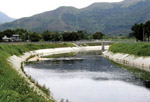
Flood Prevention Projects in the NT Flood prevention projects in the NT can broadly be classified into two main types, namely drainage channels to collect and convey floodwater to the sea and village flood pumping schemes to protect the low-lying villages in flood plain areas. While DSD is assigned to implement the majority of these projects, the Territory Development Department (TDD) also takes part in the implementation of drainage improvement works in connection with new town development projects. In 2001/02, about $0.9 billion of flood prevention projects have been substantially completed. These include a village flood pumping scheme at Pok Wai in Yuen Long and 15 km of new drainage channels to improve Ho Pui River in Kam Tin and River Indus, River Beas and River Sutlej in the North District. Work is also at an advanced stage in the construction of Middle River Indus, Ngau Tam Mei River, Upper Kam Tin River and the village flood pumping scheme at Chuk Yuen Tsuen and Ha San Wai. Apart from the on-going construction works, new works contracts were awarded last year for the construction of the Stage III works under the Shenzhen River Regulation Project, tributary channels at Upper Kam Tin River and Pok Wai, urban drainage improvement works in Yuen Long and Tin Shui Wai, and two village flood pumping schemes at Ma Tin Tsuen and Shui Pin Wai. Moreover, we commenced last year the detailed design for the drainage improvement works recommended under the two Drainage Master Plan Studies covering Sha Tin and Tai Po as well as Tuen Mun and Sham Tseng. With the completion of drainage channels over recent years, the flooding situation in the NT has been significantly improved, particularly in Lo Wu, Ho Sheung Heung and Yin Kong in the Northern NT and Tin Shui Wai, Yuen Long and Kam Tin in the Northwestern NT. In the past, floodplains in the NT were often susceptible to a flood depth of 1 m to 1.5 m as overflow took place alongside the old river sections which were narrow and sinuous. Nowadays, tens of thousands of residents in these flood prone areas have been relieved of flooding risks. The flooding situations in the Northern and Northwestern NT will be further improved upon the completion of the new drainage channels in Tin Ping Shan and Ngau Tam Mei in 2003; and the completion of the Shenzhen River Regulation Project Stage III as well as the other new drainage channels in Ta Kwu Ling, Yuen Long and San Tin in 2005. As regards low-lying villages in the flood plain areas, we have already completed 20 village flood pumping schemes to remove the flood risks at 27 low-lying villages. Over 130 hectares of low-lying villages areas accommodating a population of 20,000 people are now being protected. We will complete 7 more village flood pumping schemes before end 2005 to extend the protection to another 12 low-lying villages with a population of 7,000 people.
|
|


|
Flood Prevention Projects in Urban Areas In urban areas, apart from the traditional method of laying underground drainpipes, DSD has introduced a new approach of stormwater storage and flow transfer to minimize the traffic disruption due to trench excavations. Within the urban area in West Kowloon, the construction of about $3.3 billion of drainage improvement works is in good progress. These include 43 km of stormwater drains, a 100,000 m3 flood storage tank in Tai Hang Tung and a 1.5 km-long drainage tunnel for transferring stormwater from Kowloon Tong to the Kai Tak Nullah. All these works are scheduled to be completed progressively from 2004 to 2007 to raise the flood protection for a total population of 230,000 people in West Kowloon. The most significant improvement was seen in Mong Kok which was flooded in 1997 and 1998. In addition, the planning of 14 km of stormwater drains in Sham Shui Po district including Lai chi Kok and Cheung Sha Wan areas and a 4.2 km long drainage tunnel in Lai Chi Kok, amounting to an estimated total construction cost of $1.4 billion, are underway.
For the flood prone urban areas in the Northern Hong Kong Island, Tsuen Wan, Kwai Chung and East Kowloon, drainage improvement projects costing about $3.7 billion have been planned. In order to minimize the disturbance to the local residents and road traffic due to trench excavations in the Northern Hong Kong Island and Tsuen Wan, we would adopt the use of stormwater drainage tunnels to divert the flood flow from the existing drainage systems which are under capacity.
|


|
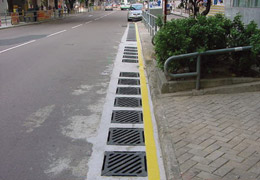
Operations and Maintenance of the Drainage System In 2001, the stormwater drainage system maintained by DSD has increased to comprise 160 km of engineered drainage channels, 2,250 km of stormwater drains and culverts and 20 village flood pumping schemes. To ensure the proper operation and functioning of the drainage system, we continue to implement a preventive maintenance programme which includes regular inspection, desilting and repair of the drainage system, particularly at locations categorized as flooding blackspots. In the past year, 1,620 km of drains, engineered channels, culverts and watercourses were inspected and 450 km of them were cleansed with 102,890 m3 of silt removed at a cost of about $124 million. We have also maintained a close connection with the Food and Environmental Hygiene Department and Highways Department to ensure that roadside gullies and drainage catchpits are in good working condition. Since 1994, DSD has identified more than a hundred flooding blackspots. All of the blackspots are under close surveillance and improvement measures have been taken to eradicate the flood risk. Up to now, more than 37 flooding blackspots have been eliminated.
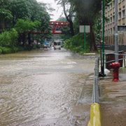
At times of heavy rainfall and severe weather conditions, DSD is also committed to dealing with emergency situations. These include monitoring the operation of all major flood control facilities, conducting immediate investigations of flooding complaints, and carrying out urgent remedial actions. Arrangements have also been made to inspect all flooding blackspots to ensure that any blockages or damage to drains and stormwater inlets are rectified in a timely manner. We have also carried out local drainage improvement works to provide immediate relief of flooding problems. For example, while the major drainage improvement works in West Kowloon are still underway, we have recently completed local improvement works at Nelson Street - a well-known flooding blackspot mainly because of the inadequate capacity of the existing stormwater drainage system. With the construction of bypass drains and new roadside gullies as short-term measures, the flood risk has been alleviated at this location which is renowned as one of the most densely populated zones and a major shopping area. Local drainage improvement works have also been completed at Fat Yip Lane, near Belvedere Garden in Tsuen Wan where several serious flooding incidents took place in June 2001 as boulders were washed into the drainage system. The operations and maintenance works carried out in the past years on flood prevention are shown in Appendix C. |
|
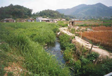
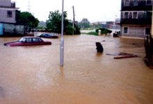
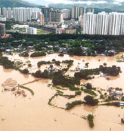
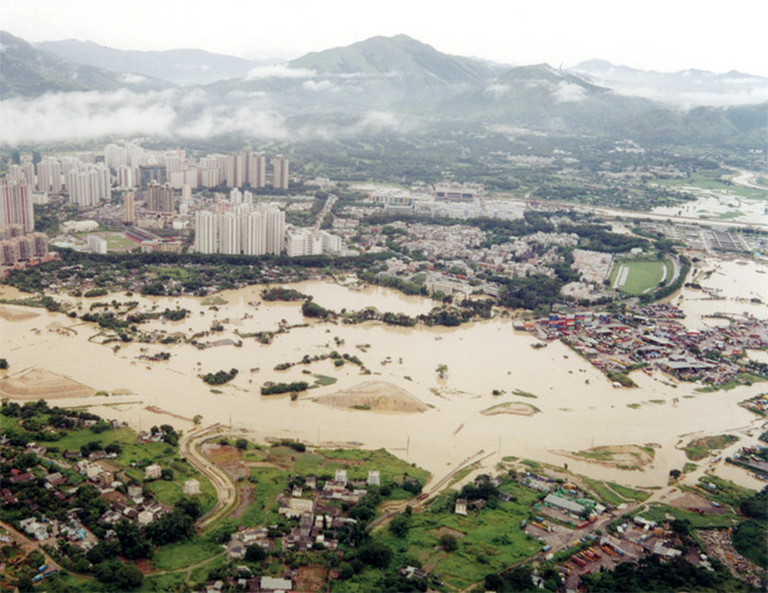
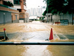
The year 2001 was wetter than usual. In June 2001, the total rainfall of 1084 mm set a new record for the month and the torrential rainfall in the period from 7.6.2001 to 11.6.2001 resulted in significant flooding in the NT and Tsuen Wan. Significant flooding incidents also occurred in Tsuen Wan due to the rainfall on 12.6.2001, 23.6.2001 and 27.6.2001. Areas affected were mainly low-lying flood prone areas alongside existing river channels. Some were in the vicinity of construction sites of government drainage projects under the management of DSD and TDD. These areas included Tin Ping Shan and Shek Wu San Tsuen in Sheung Shui, Wai Tsai Tsuen and Yau Tam Mei Tsuen in Ngau Tam Mei, Tsat Sing Kong and Tai Kong Po in Kam Tin and Pok Wai in San Tin. The HKSAR Government was deeply concerned about the flooding incidents and a Task Force led by the Secretary for Works was set up to review the flood prevention implementation programme and to identify ways to further enhance the improvement of the drainage systems. The Task Force also appointed the Director of Drainage Services to conduct an independent investigation on the causes of the flooding and to assess whether or not the construction works on site had aggravated the flooding incidents. The investigation report was completed in September 2001. It concluded that low-lying topography, inadequate drainage capacities of existing river channels, prolonged heavy rainstorms and high tide had been the principal causes of the flooding in the Northern NT. Heavy rainfall with the rising tide would have caused severe flooding even if no construction activities were taking place. Since the flooding incidents in June 2001, DSD and TDD had critically reviewed the implementation programme of the respective drainage projects already under construction and stepped up the site supervision to ensure smooth flow of river channels and stream courses, particularly under inclement weather. Both departments have strived to expedite and complete the critical sections in the relevant projects to provide early relief to the flooding before the 2002 wet season. As an interim measure, the contractors were instructed to strengthen their standby resources to deal with emergency situations arising from inclement weather. Upon completion in 2003 of the various river training works in Sheung Shui, Kam Tin and Ngau Tam Mei, the corresponding drainage systems will be significantly improved and the concerned areas, although still low-lying, will no longer be flood prone. In Pok Wai, the village flood pumping scheme has already been completed to provide the required flood protection level. In Kau Lung Hang, the planning of a flood prevention programme is now underway to improve the existing public drainage system. At Belvedere Garden, the flood risk due to boulders being washed into the drainage system has been reduced in the interim by means of local drainage improvement works while long-term improvements to further reduce the risk are being planned. |
|


|
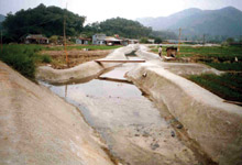
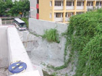
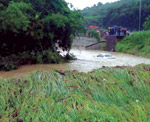
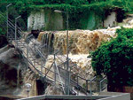
Flooding at Belvedere Garden, Tsuen Wan During the heavy rainfalls in June 2001, large quantities of muddy water flowed down along a natural stream course at the upland catchment near Belvedere Garden, Tsuen Wan. Large amount of boulders and debris were washed down from the stream course and blocked the drainage intake at Fat Yip Lane. The majority of the flow overshot the stream course as well as the drainage intake and flooded the section of Castle Peak Road opposite Belvedere Garden. As the floodwater found the way down Lai Chi Road, a section of Hoi On Road was also flooded. After the flooding incidents, the department has immediately carried out local drainage improvement works as interim measures to alleviate the drainage problem. These works included the clearance of loose boulders and debris from the stream course, shotcreting of the eroded stream course between Tuen Mun Highway and Fat Yip Lane, installation of additional bar screens at the drainage intake, construction of a solid parapet wall alongside the stream course as well as the cascade immediately upstream of the drainage intake, and construction of flow interceptors at Fat Yip Lane, Castle Peak Road, Lai Chi Road and Hoi On Road. The interim measures aimed at preventing the wash down of the boulders and debris from the eroded stream course, stabilizing the eroded stream course, confining the flow within banks, trapping the debris at the upstream to prevent the blockage of the intake at Fat Yip Lane, and enhancing the interception of the surface runoff.
After completion of the local drainage improvement works, no flooding incidents were recorded in the vicinity during the subsequent heavy rains in July and August 2001. The interim measures proved to be effective. Furthermore, the department has also employed a consultant to investigate and design the long-term drainage improvement measures. The improvement works will include the provision of additional drains and boulder traps to enhance the robustness of the existing system. Completion of these works would further reduce the flooding risks at Belvedere Garden. In the meantime, regular inspection and monitoring of the performance of the drainage intake and the public drainage system are being conducted to ensure they are functioning properly. |
|
|
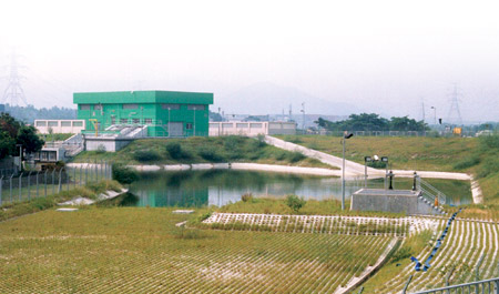
Completion of Pok Wai Village Flood Pumping Scheme
For the low-lying villages in Northwestern NT where floodwater cannot be effectively drained by gravity to the adjacent river channels, village flood pumping schemes are necessary. Pok Wai in the low-lying flood plains of Yuen Long was one of such villages prone to flooding during typhoons and heavy rainstorms. Frequent flooding incidents in the past had caused economic losses, disruption to transport and social activities, and created a threat to life to the local people. The scheme for Pok Wai village, which covers an area of about 5 hectares, forms part of the Government's overall flood control programme for the Northwestern NT. In April 2002, the village flood pumping scheme for Pok Wai was completed and put into operation. The flood protection level for the areas in Pok Wai Village has been raised from the previous less than 1 in 2 years to presently 1 in 200 years. The scheme protects the village at Pok Wai from being flooded by firstly forming a flood protection embankment and walls around the village. The embankment and walls will prevent external floodwater from entering into the village. Secondly, the scheme provides an internal stormwater drainage system to collect rainwater within the village and to convey the water to a floodwater from storage pond. Screw pumps are provided to pump out the water collected in the pond to the existing streams outside the embankment when the water level inside the floodwater storage pond reaches preset levels. In addition, the project includes widening, deepening and straightening of the existing stream in order to increase its capacity to convey the floodwater. Construction of the scheme commenced through the implementation of a major civil engineering contract in October 1999. The essential works of the scheme were completed and put into operation in April 2002. With a cost approaching $90 million, it represents another step forward in the HKSAR Government's plan to solve the flooding problem in the Northwestern NT.
|