|
|
|
|
|
 |
| |
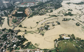
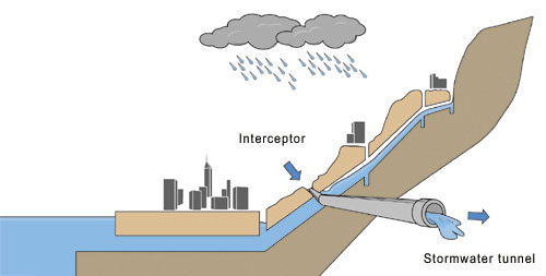
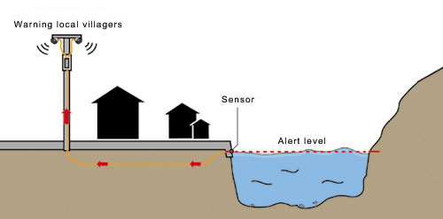
HK is on the common track of tropical cyclones in Southeast Asia and can experience very severe rainstorms at times. The average annual rainfall is about 2,200 mm, one of the highest among the cities in the Pacific Rim. Flooding can happen in the natural flood plains and low-lying areas of the northern part of the NT as well as in the older urban areas during heavy rainstorms. The intensive development in the flood plains over the years has transformed large areas of natural ground into hard paved areas, thus reducing their storage capacity. Rainwater quickly becomes surface flows and aggravates the flooding problem. Flooding can also occur in older urban areas because of the inadequacy of the stormwater drainage systems that were built decades ago to the old flood protection standards and of the increased runoff as a result of developments in upstream areas.
|
|
|
Flood Protection Standards
|
|
Long Term Improvement
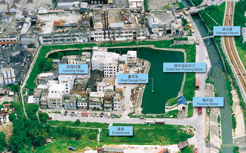
Works As for the low-lying villages where floodwater cannot effectively be drained by gravity to the adjacent river channels, village flood protection schemes are necessary. A protective bund and a pumping station are built to prevent floodwater from entering the village and to pump the rainwater out of the village area. In the urban areas, drainage improvement works are often hindered by the lack of space and difficulties in diverting traffic or utility. To reduce disruption and inconvenience caused by road opening, the following options are considered:
|
|
Operations and Maintenance Timely repairs will be carried out before major problems arise. Regular desilting is conducted to ensure that the flood carrying capacities will not be adversely affected by sediment washed into the drainage system. Coordinated efforts amongst relevant Government departments in keeping the streets clean to prevent rubbish from blocking the roadside gullies and catch pits are also important. In 2000, 1,542 km of drains, engineered channels, culverts and watercourses were inspected and 393 km of them were cleansed with 270,000 m3 of silt removed at a cost of about $135 million. The volume of silt removed and the associated expenditure in past years are shown in Table C1 of Appendix C.
An Emergency and Storm
Damage Organization is established to handle emergency and flooding problems.
When a situation warrants to co-ordinate emergency clearance of blocked
drains and watercourses, an Emergency Control Centre overseen by senior
professionals will be activated to handle complaints and reports of flooding,
and to disseminate information within the Government and to the public.
Crucial hydraulic structures, such as facilities within the flood pumping
station and the inflatable dams at major channels constructed for stormwater
quality improvement, are closely monitored by the monitoring and control
system, and video surveillance.
|
|
Mitigation
Measures
|
|
Non-structural Measures Land use management involves administrative procedures to control developments in drainage catchments of the NT without increasing their flood risk. Any developments requiring a change in the land use specified in the Outline Zoning Plans or other development plans will need to seek approval from the Town Planning Board. If the developments will have significant impacts on the drainage condition, the project proponents, private or government, are required to conduct a Drainage Impact Assessment and to propose necessary mitigating measures to ensure that the flood risk of the concerned area will not increase. Many natural watercourses in the NT lie within private land. The Land Drainage Ordinance, enacted in 1994, empowered the department to gain access into private land to carry out necessary maintenance works and to remove obstructions, such as illegal structures, encroaching upon the designated main watercourses.
|
|
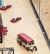
Significant Floods
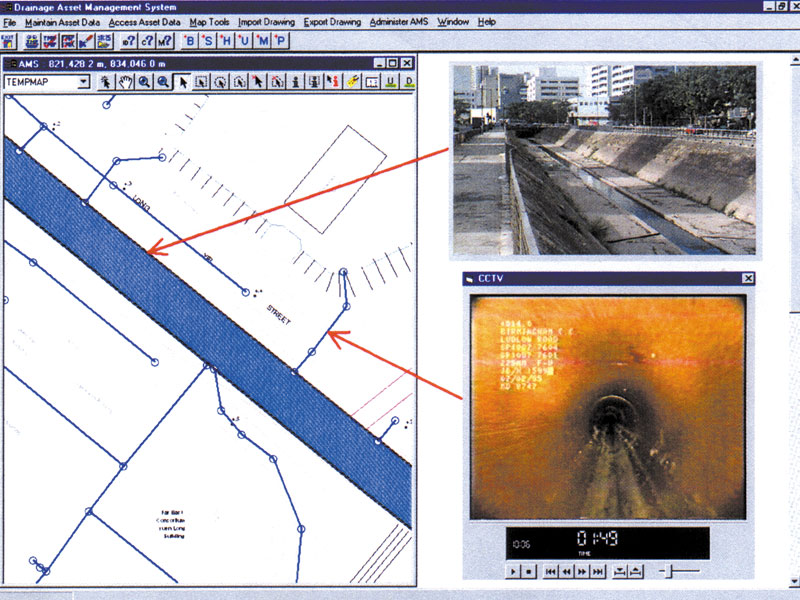
in 2000 Sheung Cheung Wai in Tin Shui Wai and Tsz Tin Tsuen in Tuen Mun were severely flooded due to inadequate drainage. The flooding situation was aggravated by the construction activities which were taking place in the adjacent drainage channels. Another significant flood occurred on 24.8.2000. Typhoon Bilis brought about very heavy rainfall, especially on HK Island. In the early morning hours, the Black Rainstorm Warning Signal was issued. A total of ten major flooding incidents were reported, nine of them were on HK Island and one in Shatin. They included the flooding incidents at the race course of the Hong Kong Jockey Club in Happy Valley and in Hennessy Road, Ship Street, Canal Road in Wanchai, and the Pok Fu Lam Village in the Southern District. There were also flood damages under the effect of fast flowing surface water running down steep roads and stairways in the Mid-Level. The major causes of these flooding incidents were due to inadequate drainage capacity, blockage at catchpits and roadside gullies, and construction activities. Apart from major projects already scheduled for implementation in the coming years, the department has implemented a number of measures to minimize the flood risk. For areas in the NT, we have strengthened our control over the temporary works erected over watercourses due to the construction of the West Rail. A dedicated team has been set up to examine and approve the design of the temporary works and to carry out regular monitoring and auditing to ensure that no adverse drainage impact will be caused due to construction of West Rail. For the drainage networks on HK Island, we have critically reviewed the concerned stormwater drains by means of CCTV to ensure that the conveyance of stormwater are not susceptible to obstruction. We have also carried out a number of local drainage improvement works. They include the desilting of stormwater drains and installation of grilles at stormwater inlets to avoid blockage due to ingress of boulders or other sizable objects.
|
|
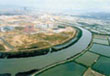
Completion of Shenzhen
River Regulation Stage II In June 2000, we achieved another milestone for the project, i.e. completion of the Stage II works that involved the widening, deepening and straightening of the river channel from Lo Wu to the river estuary at Deep Bay. The regulation work at the river channel from Liu Pok to Lok Ma Chau was completed in 1999 while that for the section from Lok Ma Chau to the river estuary at Deep Bay was completed in 2000. We had now completed 10 km of new river channels with the river channel at Liu Pok (just west of Lo Wu) widened to 105 m and to 210 m at the river estuary. The flood protection level for the areas adjacent to the trained section of the Shenzhen River has been raised from the previous 1 in 2-5 years to presently 1 in 50 years. During a 1 in 50 years storm, the water level at Lo Wu will be lowered than before by two metres. The improvement to the Shenzhen River is a corner stone of DSD's flood mitigation strategy in the Northern NT as it is now able to convey the extra flood flow from the catchment of River Indus where various river training works are well underway for completion in the next few years commencing 2001. The river training works in Stages I and II were entrusted to the Shenzhen side and were carried out under two separate contracts. We are now working hand in hand with the Shenzhen River regulation Office on the Stage III works to train the section of Lo Wu, up to the confluence with River Ganges.
|